
Tormos to Isbert’s dam via Pla de Costera
A delightful walk along the flanks of the Mediodia and then into the heart of the Llaguart valley before returning on tracks through forestry and river bed.
One section of bamboo currently impassable due to bamboo growth.
Spanish maps included within these descriptions are provided courtesy of the Spanish IGN and remain © Instituto Geográfico Nacional.
OSM (OpenStreetMap) and OCM (OpenCycleMap) maps are © OpenStreetMap Contributors. The OSM project welcomes contributions from all to enrich the map data, which is made freely available. Land (Thunderforest Landscape) maps are © Thunderforest based on data © OpenStreetMap contributors.
The grade of this walk is MS/B, which means
MS – Moderately Strenuous: Up to 600 metres ascent and/or no more than 15 km in length with some rough going taken at a reasonable pace.
B – Less than half the route on rough ground
| Nearest town | Tormos |
| Directions to start |
Coming from the south (Orba) on the CV715 at the outskirts of the village turn L (signposted to Costera del Moll) into Calle Pozo. Take the next L (Carrer Val de Llaguart) and then take the 2nd turn on the RHS just after the bins. Drive to the end opposite a plaza and turn L into Avenguda Joan Carles I. Drive a few hundred metres along this past the playground and piscina and park on open ground 50m further on the LHS |
| Start point (Lat/Long) | 38.798900, -0.077100 Click here to view in Google Maps (in a new browser tab) |
| Length (km) | 12.00 |
| Ascent (metres) | 470 |
| Walking time (hours) | 3.25 |
| Total time (hours) | 5.00 |
| Recommendations or Restrictions | One section of bamboo currently impassable due to bamboo growth. See description for details. |
Download walk descriptionDownload GPS file
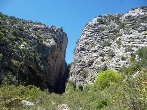
Enjoyable walk, much variety. Every landscape type you can think of is included.