
Las Vegas circuit
Lovely varied circuit with many points of interest.
Spanish maps included within these descriptions are provided courtesy of the Spanish IGN and remain © Instituto Geográfico Nacional.
OSM (OpenStreetMap) and OCM (OpenCycleMap) maps are © OpenStreetMap Contributors. The OSM project welcomes contributions from all to enrich the map data, which is made freely available. Land (Thunderforest Landscape) maps are © Thunderforest based on data © OpenStreetMap contributors.
The grade of this walk is M/B, which means
M – Moderate: up to 12km in length, less than 400 metres ascent and less than 50% rough going.
B – Less than half the route on rough ground
| Nearest town | Las Vegas |
| Directions to start |
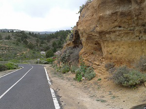
From the Autopista Sur take the turn off to Chimiche and head up and through the village to the crossroads with the TF-28. Go straight on (signposted Las Vegas) and continue for about 2.7km until just before a left hand bend you see on the right an area to park beside some low cliffs, a signpost and some steps cut into the rock (see photo). |
| Start point (Lat/Long) | 28.148190, -16.546850 Click here to view in Google Maps (in a new browser tab) |
| Length (km) | 7.00 |
| Ascent (metres) | 300 |
| Walking time (hours) | 2.50 |
| Total time (hours) | 2.75 |
| Recommendations or Restrictions | Navigation is straightforward and there are no difficult sections. |
Download walk descriptionDownload GPS file
Comments
Las Vegas circuit — No Comments
HTML tags allowed in your comment: <a href="" title=""> <abbr title=""> <acronym title=""> <b> <blockquote cite=""> <cite> <code> <del datetime=""> <em> <i> <q cite=""> <s> <strike> <strong>