
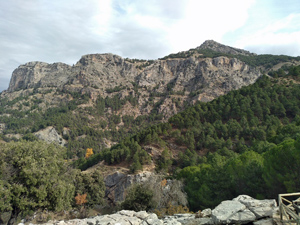
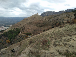
Cazorla hills and castles
A delightful round of the nearby hills directly from Cazorla town with the opportunity to explore 2 of the castles in the area.
Spanish maps included within these descriptions are provided courtesy of the Spanish IGN and remain © Instituto Geográfico Nacional.
OSM (OpenStreetMap) and OCM (OpenCycleMap) maps are © OpenStreetMap Contributors. The OSM project welcomes contributions from all to enrich the map data, which is made freely available. Land (Thunderforest Landscape) maps are © Thunderforest based on data © OpenStreetMap contributors.
The grade of this walk is MS/A, which means
MS – Moderately Strenuous: Up to 600 metres ascent and/or no more than 15 km in length with some rough going taken at a reasonable pace.
A – All on good tracks
| Nearest town | Cazorla |
| Directions to start |
From the A92N motorway which runs between Puerto Lumbreras and Granada take the A315 going N and then the A319 to arrive at Cazorla. |
| Start point (Lat/Long) | 37.908987, -3.000226 Click here to view in Google Maps (in a new browser tab) |
| Length (km) | 12.00 |
| Ascent (metres) | 590 |
| Walking time (hours) | 3.25 |
| Total time (hours) | 5.5 |
| Recommendations or Restrictions | None. Plaza Santa Maria is the old square in Cazorla and not the remote location used to start this walk. |
Download walk descriptionDownload GPS file
Comments
Cazorla hills and castles — No Comments
HTML tags allowed in your comment: <a href="" title=""> <abbr title=""> <acronym title=""> <b> <blockquote cite=""> <cite> <code> <del datetime=""> <em> <i> <q cite=""> <s> <strike> <strong>