
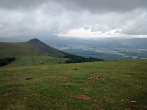
GR11 – Day 6. Puerto de Urkiaga to Burguete.
A mixed walk through tree clad slopes to vast open ridges with wide views eventually descending to join the peregrinos of the Camino de Santiago.
Spanish maps included within these descriptions are provided courtesy of the Spanish IGN and remain © Instituto Geográfico Nacional.
OSM (OpenStreetMap) and OCM (OpenCycleMap) maps are © OpenStreetMap Contributors. The OSM project welcomes contributions from all to enrich the map data, which is made freely available. Land (Thunderforest Landscape) maps are © Thunderforest based on data © OpenStreetMap contributors.
The grade of this walk is VS/A, which means
VS – Very Strenuous: More than 800 metres ascent and/or more than 20km in length with steep, loose or heavily vegetated sections.
A – All on good tracks
| Nearest town | Eugi |
| Directions to start |
From the village of Eugi drive 12km N of the village on the NA138 to reach a large rough parking area at the col on the RHS. Start here. |
| Start point (Lat/Long) | 43.036167, -1.470497 Click here to view in Google Maps (in a new browser tab) |
| Length (km) | 19.20 |
| Ascent (metres) | 820 |
| Walking time (hours) | 4.75 |
| Total time (hours) | 6.00 |
| Recommendations or Restrictions | None |
Download walk descriptionDownload GPS file

Comments
GR11 – Day 6. Puerto de Urkiaga to Burguete. — No Comments
HTML tags allowed in your comment: <a href="" title=""> <abbr title=""> <acronym title=""> <b> <blockquote cite=""> <cite> <code> <del datetime=""> <em> <i> <q cite=""> <s> <strike> <strong>