
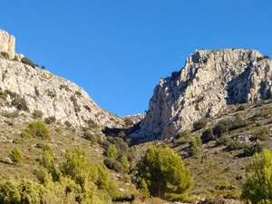
‘More than Morro Blau’
A woodland path leads to a mirador above embalse de Guadalest ,then a gully scramble leads up to panoramic views on the summit and return down the sides of a barranco and another woodland path.
Spanish maps included within these descriptions are provided courtesy of the Spanish IGN and remain © Instituto Geográfico Nacional.
OSM (OpenStreetMap) and OCM (OpenCycleMap) maps are © OpenStreetMap Contributors. The OSM project welcomes contributions from all to enrich the map data, which is made freely available. Land (Thunderforest Landscape) maps are © Thunderforest based on data © OpenStreetMap contributors.
The grade of this walk is VS/C/Scr, which means
VS – Very Strenuous: More than 800 metres ascent and/or more than 20km in length with steep, loose or heavily vegetated sections.
C – More than half the route on rough ground.
Scr – Scrambling: This implies the need for handholds to ascend steep rock pitches with a sense of exposure to vertigo and where a slip could lead to a serious accident.
| Nearest town | Callosa d’en Sarria |
| Directions to start |
From Altea direction at main roundabout in Callosa take 2nd street on R (Avinguda Jaume 1) then R fork in front of Banco Santander – go up hill then downhill, cross a junction and turn up Calle Callosa D’en Sarria -continue for 2.7Kms on narrow surfaced road (pass Urb. Almedia at RHS ) and follow to park near a concrete casita. |
| Start point (Lat/Long) | 38.672417, -0.134233 Click here to view in Google Maps (in a new browser tab) |
| Length (km) | 14.00 |
| Ascent (metres) | 830 |
| Walking time (hours) | 4.50 |
| Total time (hours) | 5.50 |
| Recommendations or Restrictions | A tough scramble ascent and a short section of rough downhill path. |
Download walk descriptionDownload GPS file

Done on 27/12/2025.Great walk,very wild,beautiful views.