
Orihuela del Tremedal
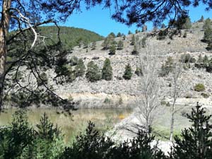
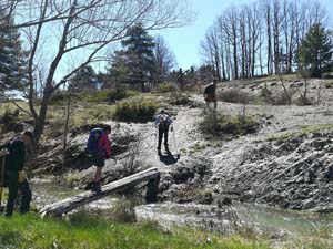
This beautiful and varied walk largely follows the GR 10.1 and the SL TE. We continue through the village towards Plaza del Torros. Just outside the village we leave the paved road, cross the river via a gangway and continue to follow the river bank on an indistinct path. Pass a lake with waterfowl and then climb on a clear and wide path towards Caimodorro (the highest peak of the Serra de Albarracin/Montes Universalis).
Spanish maps included within these descriptions are provided courtesy of the Spanish IGN and remain © Instituto Geográfico Nacional.
OSM (OpenStreetMap) and OCM (OpenCycleMap) maps are © OpenStreetMap Contributors. The OSM project welcomes contributions from all to enrich the map data, which is made freely available. Land (Thunderforest Landscape) maps are © Thunderforest based on data © OpenStreetMap contributors.
The grade of this walk is S/B, which means
S – Strenuous: More than 600 metres ascent and/or more than 15km in length with steep, loose or heavily vegetated sections.
B – Less than half the route on rough ground.
| Nearest town | Orihuela del Tremedal |
| Directions to start |
From the A23 motorway running from Valencia NW past Teruel. Orihuela de Tremedal lies NW of Teruel on the TE V9021 and A1511 road. |
| Start point (Lat/Long) | 40.549607, -1.649344 Click here to view in Google Maps (in a new browser tab) |
| Length (km) | 15.00 |
| Ascent (metres) | 675 |
| Walking time (hours) | 3.5 |
| Total time (hours) | 5.33 |
| Recommendations or Restrictions | None |
Download walk descriptionDownload GPS file


Comments
Orihuela del Tremedal — No Comments
HTML tags allowed in your comment: <a href="" title=""> <abbr title=""> <acronym title=""> <b> <blockquote cite=""> <cite> <code> <del datetime=""> <em> <i> <q cite=""> <s> <strike> <strong>