
Ruta dels Assegadors and Sierra Gallinera
Mainly on well walked PR paths, through pine woods the odd mountain and a bit of history.
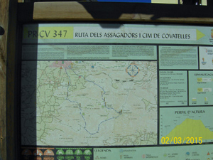
Spanish maps included within these descriptions are provided courtesy of the Spanish IGN and remain © Instituto Geográfico Nacional.
OSM (OpenStreetMap) and OCM (OpenCycleMap) maps are © OpenStreetMap Contributors. The OSM project welcomes contributions from all to enrich the map data, which is made freely available. Land (Thunderforest Landscape) maps are © Thunderforest based on data © OpenStreetMap contributors.
The grade of this walk is VS/B, which means
VS – Very Strenuous: More than 800 metres ascent and/or more than 20km in length with steep, loose or heavily vegetated sections.
B – Less than half the route on rough ground.
| Nearest town | La Font d’en Carros |
| Directions to start |
From the north end of Oliva on N332 take the road to la Font d’En Caroos. At the 2nd roundabout turn left and follow signs to tourist office. Avingunda Excelencia Deputado left fork to halt sign, turn left past font and town hall and straight ahead into C/ Abdon y Senet. Park in the square. |
| Start point (Lat/Long) | 38.916124, -0.168931 Click here to view in Google Maps (in a new browser tab) |
| Length (km) | 14.00 |
| Ascent (metres) | 801 |
| Walking time (hours) | 5 |
| Total time (hours) | 5.00 |
| Recommendations or Restrictions | None |
Download walk descriptionDownload GPS file
Comments
Ruta dels Assegadors and Sierra Gallinera — No Comments
HTML tags allowed in your comment: <a href="" title=""> <abbr title=""> <acronym title=""> <b> <blockquote cite=""> <cite> <code> <del datetime=""> <em> <i> <q cite=""> <s> <strike> <strong>