
Plan de Banhs circuit to Colomers and return
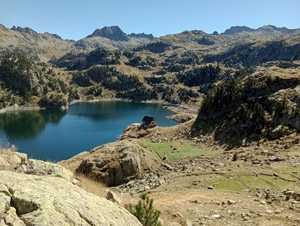
A challenging circuit to Estanh Major de Colomers and return along river route.
Spanish maps included within these descriptions are provided courtesy of the Spanish IGN and remain © Instituto Geográfico Nacional.
OSM (OpenStreetMap) and OCM (OpenCycleMap) maps are © OpenStreetMap Contributors. The OSM project welcomes contributions from all to enrich the map data, which is made freely available. Land (Thunderforest Landscape) maps are © Thunderforest based on data © OpenStreetMap contributors.
The grade of this walk is S/B, which means
S – Strenuous: More than 600 metres ascent and/or more than 15km in length with steep, loose or heavily vegetated sections.
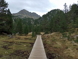
B – Less than half the route on rough ground.
| Nearest town | Salardu |
| Directions to start |
From Vileha follow the C28 as far as Salardu and look for a minor road to the R from the second roundabout signed to Banhs de Tredos. |
| Start point (Lat/Long) | 42.656300, 0.927040 Click here to view in Google Maps (in a new browser tab) |
| Length (km) | 12.50 |
| Ascent (metres) | 635 |
| Walking time (hours) | 5 |
| Total time (hours) | 6.5 |
| Recommendations or Restrictions | None |
Download walk descriptionDownload GPS file


Comments
Plan de Banhs circuit to Colomers and return — No Comments
HTML tags allowed in your comment: <a href="" title=""> <abbr title=""> <acronym title=""> <b> <blockquote cite=""> <cite> <code> <del datetime=""> <em> <i> <q cite=""> <s> <strike> <strong>