
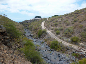
Teide from Sea to Summit – Playa de las Americas to Arona
A starter walk to get you going on your ascent of Teide or the GR131. Much tarmac but also some grand scenery and a mozarabic path.
Spanish maps included within these descriptions are provided courtesy of the Spanish IGN and remain © Instituto Geográfico Nacional.
OSM (OpenStreetMap) and OCM (OpenCycleMap) maps are © OpenStreetMap Contributors. The OSM project welcomes contributions from all to enrich the map data, which is made freely available. Land (Thunderforest Landscape) maps are © Thunderforest based on data © OpenStreetMap contributors.
The grade of this walk is VS/A, which means
VS – Very Strenuous: More than 800 metres ascent and/or more than 20km in length with steep, loose or heavily vegetated sections.
A – All on good tracks
| Nearest town | Teide from Sea to Summit |
| Directions to start |
If coming by bus arrive at Adeje bus station and walk back a little to the S to reach the roundabout on the TF481 with the large structure of the Magma arts centre. |
| Start point (Lat/Long) | 28.068712, -16.727198 Click here to view in Google Maps (in a new browser tab) |
| Length (km) | 13.50 |
| Ascent (metres) | 1170 |
| Walking time (hours) | 3.50 |
| Total time (hours) | 0.00 |
| Recommendations or Restrictions | Need transport at the end of the walk. |
Download walk descriptionDownload GPS file
Comments
Teide from Sea to Summit – Playa de las Americas to Arona — No Comments
HTML tags allowed in your comment: <a href="" title=""> <abbr title=""> <acronym title=""> <b> <blockquote cite=""> <cite> <code> <del datetime=""> <em> <i> <q cite=""> <s> <strike> <strong>