
Adsubia Circuit
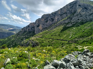
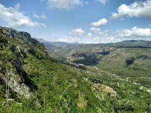
A hilly ramble across the mountains around Adsubia with great views of the Gallinera valley.
Spanish maps included within these descriptions are provided courtesy of the Spanish IGN and remain © Instituto Geográfico Nacional.
OSM (OpenStreetMap) and OCM (OpenCycleMap) maps are © OpenStreetMap Contributors. The OSM project welcomes contributions from all to enrich the map data, which is made freely available. Land (Thunderforest Landscape) maps are © Thunderforest based on data © OpenStreetMap contributors.
The grade of this walk is MS/B, which means
MS – Moderately Strenuous: Up to 600 metres ascent and/or no more than 15 km in length with some rough going taken at a reasonable pace.
B – Less than half the route on rough ground
| Nearest town | Adsubia |
| Directions to start |
Follow CV700 from Pego to Adsubia. Towards the end of the village turn left at Bar Moleta and park where convenient. |
| Start point (Lat/Long) | 38.848227, -0.152022 Click here to view in Google Maps (in a new browser tab) |
| Length (km) | 13.00 |
| Ascent (metres) | 540 |
| Walking time (hours) | 3.25 |
| Total time (hours) | 4.50 |
| Recommendations or Restrictions | None |
Download walk descriptionDownload GPS file
As of March 2021 the signposts mentioned are still extant. Some of the poles with y/w stripes have been replaced by PR signs. Instructions v easy to follow until we got to the deposito – but it was easy to tell which way to go even without consulting the phone for the GPS track.