
Bernia West Summit
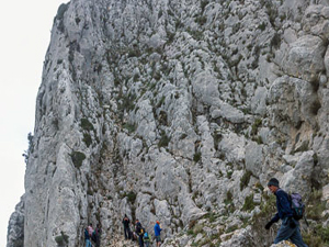
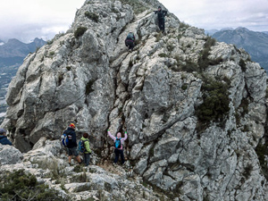
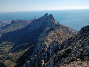
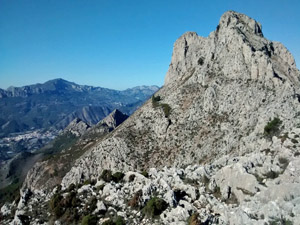
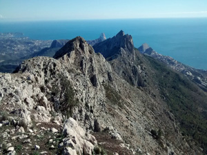
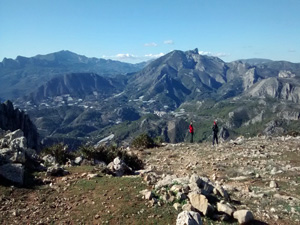
This exciting walk combines part of the well known Bernia Circuit route with the ascent of the west summit. Our version of this walk starts on the south side of the impressive Bernia Mountain Range. Good waymarked paths and tracks lead round the west side passing through the remains of Fort Bernia (built during the reign of Philip II of Spain to control and suppress the Moorish uprisings). A path from the north side starts the ascent through a shrub area. Then the going gets tough as the climb continues up and across rough scree to reach a rake. The scramble up this rake (not recommended in very windy conditions) gains the top of the ridge. The best way across the ridge to the west summit is waymarked. The ridge traverse is exciting and involves a few interesting scrambles, the toughest of which are now made easier with the aid of chains and ropes. Reaching the summit is rewarded with extensive views and a sense of accomplishment. The descent, however, is not a walk in the park. It requires more scrambling with chain and rope followed by a steep, often loose surfaced path back down to the Fort.
Spanish maps included within these descriptions are provided courtesy of the Spanish IGN and remain © Instituto Geográfico Nacional.
OSM (OpenStreetMap) and OCM (OpenCycleMap) maps are © OpenStreetMap Contributors. The OSM project welcomes contributions from all to enrich the map data, which is made freely available. Land (Thunderforest Landscape) maps are © Thunderforest based on data © OpenStreetMap contributors.
The grade of this walk is S/C/Scr/X, which means
S – Strenuous: More than 600 metres ascent and/or more than 15km in length with steep, loose or heavily vegetated sections.
C – More than half the route on rough ground.
Scr – Scrambling: This implies the need for handholds to ascend steep rock pitches with a sense of exposure to vertigo and where a slip could lead to a serious accident.
X – Experienced walkers route: the route requires considerable stamina and/or significant scrambling skills on rough, steep or exposed sections.
| Nearest town | Benissa |
| Directions to start |
In the town of Jalon look travel along the main village street (not the by-pass) and look for a turning south on the CV749. Follow this for some 11.5km and at a T-jnc where the main road turns L continue straight ahead to the first bend and park on the L in the trees. |
| Start point (Lat/Long) | 38.672201, -0.046091 Click here to view in Google Maps (in a new browser tab) |
| Length (km) | 10.40 |
| Ascent (metres) | 735 |
| Walking time (hours) | 4.50 |
| Total time (hours) | 5.25 |
| Recommendations or Restrictions |
Download walk descriptionDownload GPS file
Comments
Bernia West Summit — No Comments
HTML tags allowed in your comment: <a href="" title=""> <abbr title=""> <acronym title=""> <b> <blockquote cite=""> <cite> <code> <del datetime=""> <em> <i> <q cite=""> <s> <strike> <strong>