
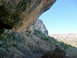
Caballo Verde West
A demanding excursion over and along the western flanks of the Caballo Verde ridge visiting interesting features normally unfrequented.
Spanish maps included within these descriptions are provided courtesy of the Spanish IGN and remain © Instituto Geográfico Nacional.
OSM (OpenStreetMap) and OCM (OpenCycleMap) maps are © OpenStreetMap Contributors. The OSM project welcomes contributions from all to enrich the map data, which is made freely available. Land (Thunderforest Landscape) maps are © Thunderforest based on data © OpenStreetMap contributors.
The grade of this walk is S/C, which means
S – Strenuous: More than 600 metres ascent and/or more than 15km in length with steep, loose or heavily vegetated sections.
C – More than half the route on rough ground.
| Nearest town | Benichembla |
| Directions to start |
From Benichembla follow the CV720 for a short distance until you pass the 80kph marker and just past this and opposite a house turn R down a tarmacked road. |
| Start point (Lat/Long) | 38.758208, -0.137802 Click here to view in Google Maps (in a new browser tab) |
| Length (km) | 13.50 |
| Ascent (metres) | 720 |
| Walking time (hours) | 4.00 |
| Total time (hours) | 5.25 |
| Recommendations or Restrictions | Grit, determination and navigational skills are required for this outing. |
Download walk descriptionDownload GPS file


Comments
Caballo Verde West — No Comments
HTML tags allowed in your comment: <a href="" title=""> <abbr title=""> <acronym title=""> <b> <blockquote cite=""> <cite> <code> <del datetime=""> <em> <i> <q cite=""> <s> <strike> <strong>