
GR11 – Day 34 – La Cotinada to Encamp
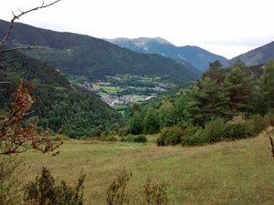
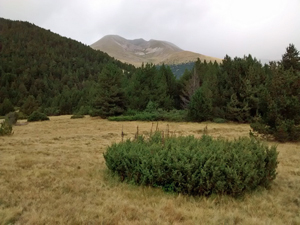
An early walk in the woods followed by more open terrain with grand views as you descend to Encamp.
Spanish maps included within these descriptions are provided courtesy of the Spanish IGN and remain © Instituto Geográfico Nacional.
OSM (OpenStreetMap) and OCM (OpenCycleMap) maps are © OpenStreetMap Contributors. The OSM project welcomes contributions from all to enrich the map data, which is made freely available. Land (Thunderforest Landscape) maps are © Thunderforest based on data © OpenStreetMap contributors.
The grade of this walk is VS/B, which means
VS – Very Strenuous: More than 800 metres ascent and/or more than 20km in length with steep, loose or heavily vegetated sections.
B – Less than half the route on rough ground.
| Nearest town | La Cotinada |
| Directions to start |
La Cotinada lies to the N of Ordino – a popular tourist town – on the CG3 road. |
| Start point (Lat/Long) | 42.576069, 1.518679 Click here to view in Google Maps (in a new browser tab) |
| Length (km) | 13.50 |
| Ascent (metres) | 1175 |
| Walking time (hours) | 4.5 |
| Total time (hours) | 6 |
| Recommendations or Restrictions | None |
Download walk descriptionDownload GPS file
Comments
GR11 – Day 34 – La Cotinada to Encamp — No Comments
HTML tags allowed in your comment: <a href="" title=""> <abbr title=""> <acronym title=""> <b> <blockquote cite=""> <cite> <code> <del datetime=""> <em> <i> <q cite=""> <s> <strike> <strong>