
Pico Jano circuit from Dobarganes
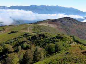
A wonderful walk up delightful wooded slopes to a small peak that has 360 degree views into the heart of the Picos de Europa and back to many of the peaks of the Cordillera Cantabrica. Well worth the effort.
Spanish maps included within these descriptions are provided courtesy of the Spanish IGN and remain © Instituto Geográfico Nacional.
OSM (OpenStreetMap) and OCM (OpenCycleMap) maps are © OpenStreetMap Contributors. The OSM project welcomes contributions from all to enrich the map data, which is made freely available. Land (Thunderforest Landscape) maps are © Thunderforest based on data © OpenStreetMap contributors.
The grade of this walk is MS/B, which means
MS – Moderately Strenuous: Up to 600 metres ascent and/or no more than 15 km in length with some rough going taken at a reasonable pace.
B – Less than half the route on rough ground
| Nearest town | Dobarganes |
| Directions to start |
From Potes – the main town in the Liebana valley of the Picos take the N621 road and follow this for just over 14km to find a turning on the R signed to Dobarganes. Follow this for 2km and continue to find a set of bins on the LHS in a small “shed” beside an information board next to it with info about the walk – the PR |
| Start point (Lat/Long) | 43.102934, -4.693253 Click here to view in Google Maps (in a new browser tab) |
| Length (km) | 9.50 |
| Ascent (metres) | 600 |
| Walking time (hours) | 2.75 |
| Total time (hours) | 4 |
| Recommendations or Restrictions | Best done in Autumn (think first couple of weeks of October) for the tree colours. Take care to avoid the fissure – see description. |
Download walk descriptionDownload GPS file


We got lost twice in the last part, because the trail is not marked and there are a few splits. This was a very annoying end of this fabulous track!
Hope it didn’t spoil it too much. Always best to use the gps track as an aid if you can.