
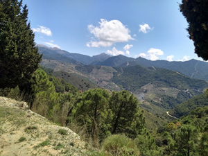
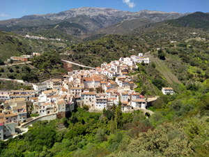
Salares to Cruz de Muerto circuit
A mixed walk with delightful sections with mountain and coastal views and some tough and challenging paths requiring skilled navigation.
Spanish maps included within these descriptions are provided courtesy of the Spanish IGN and remain © Instituto Geográfico Nacional.
OSM (OpenStreetMap) and OCM (OpenCycleMap) maps are © OpenStreetMap Contributors. The OSM project welcomes contributions from all to enrich the map data, which is made freely available. Land (Thunderforest Landscape) maps are © Thunderforest based on data © OpenStreetMap contributors.
The grade of this walk is MS/B, which means
MS – Moderately Strenuous: Up to 600 metres ascent and/or no more than 15 km in length with some rough going taken at a reasonable pace.
B – Less than half the route on rough ground
| Nearest town | Salares |
| Directions to start |
Drive up from the coast to Archez and then take the MA4108 until you drop down a hill and find Salares on your RHS (not visible until the last minute). Turn R towards the village and park in any of the parking spaces on either side of the road. |
| Start point (Lat/Long) | 36.853490, -4.025597 Click here to view in Google Maps (in a new browser tab) |
| Length (km) | 12.00 |
| Ascent (metres) | 580 |
| Walking time (hours) | 3.5 |
| Total time (hours) | 5.25 |
| Recommendations or Restrictions | There are several very challenging section on this route along with the possibility that you might be challenged for trespass around km 7.8 (see description). Only undertake it if you are up for a challenging but rewarding day out! |
Download walk descriptionDownload GPS file
Comments
Salares to Cruz de Muerto circuit — No Comments
HTML tags allowed in your comment: <a href="" title=""> <abbr title=""> <acronym title=""> <b> <blockquote cite=""> <cite> <code> <del datetime=""> <em> <i> <q cite=""> <s> <strike> <strong>