
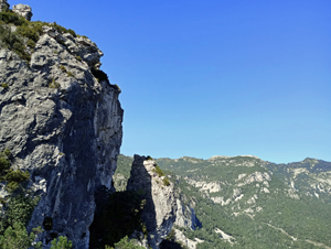
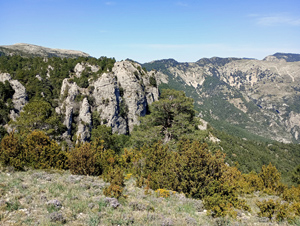
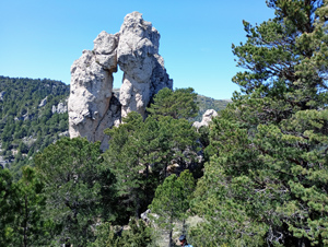
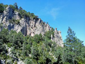
Toscar ridge and Roca Campanari circuit
A stunning walk leading to a rock staple with a boulder held between its two prongs!
Spanish maps included within these descriptions are provided courtesy of the Spanish IGN and remain © Instituto Geográfico Nacional.
OSM (OpenStreetMap) and OCM (OpenCycleMap) maps are © OpenStreetMap Contributors. The OSM project welcomes contributions from all to enrich the map data, which is made freely available. Land (Thunderforest Landscape) maps are © Thunderforest based on data © OpenStreetMap contributors.
The grade of this walk is S/C, which means
S – Strenuous: More than 600 metres ascent and/or more than 15km in length with steep, loose or heavily vegetated sections.
C – More than half the route on rough ground.
| Nearest town | Els Reguers |
| Directions to start |
From the C12 near Tortosa find the road towards and through Roquetes and Els Reguers before turning off to the L at a sign to El Tosca. Follow this road with signs as it slowly winds its way along a valley to arrive at a cluster of buildings with parking and a notice board. (It is possible to drive further but you’ll have to walk further at the end of the walk to retrieve your car!) |
| Start point (Lat/Long) | 40.846300, 0.354200 Click here to view in Google Maps (in a new browser tab) |
| Length (km) | 8.50 |
| Ascent (metres) | 675 |
| Walking time (hours) | 3 |
| Total time (hours) | 5.5 |
| Recommendations or Restrictions | Challenging steepness all day long. |
Download walk descriptionDownload GPS file
Comments
Toscar ridge and Roca Campanari circuit — No Comments
HTML tags allowed in your comment: <a href="" title=""> <abbr title=""> <acronym title=""> <b> <blockquote cite=""> <cite> <code> <del datetime=""> <em> <i> <q cite=""> <s> <strike> <strong>