
Tossal Trails Extra
Steady climbing over Tossal del Moro then more of the same to reach the summit of Serrellars. pleasant paths lead back, across the southern flanks. Wonderful views.
Spanish maps included within these descriptions are provided courtesy of the Spanish IGN and remain © Instituto Geográfico Nacional.
OSM (OpenStreetMap) and OCM (OpenCycleMap) maps are © OpenStreetMap Contributors. The OSM project welcomes contributions from all to enrich the map data, which is made freely available. Land (Thunderforest Landscape) maps are © Thunderforest based on data © OpenStreetMap contributors.
The grade of this walk is MS/B, which means
MS – Moderately Strenuous: Up to 600 metres ascent and/or no more than 15 km in length with some rough going taken at a reasonable pace.
B – Less than half the route on rough ground
| Nearest town | Benissa |
| Directions to start |
Benissa motorway tunnels. From Benissa take the access road to the motorway on the roundabout take a minor exit signed to the Cementerio. Do not turn of to the cemetery but continue on this track for 2.2km parallel to the motorway until you reach a tunnel and park there. Be aware your GPS might try and take you onto the motorway! |
| Start point (Lat/Long) | 38.743109, 0.053247 Click here to view in Google Maps (in a new browser tab) |
| Length (km) | 10.00 |
| Ascent (metres) | 502 |
| Walking time (hours) | 3.5 |
| Total time (hours) | 5 |
| Recommendations or Restrictions | There is alternative parking beside the enclosed well about 500 metres before reaching the tunnels, some may prefer it. The GPS track passes through here. |
Download walk descriptionDownload GPS file
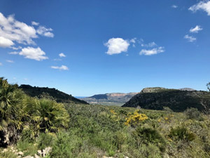
Really good walk, with great view practically the whole way.
Quite steep right from the start up to Tossal del Moro, with 1 section of around 30-50m where hands are needed. Probably a good idea to use the alternative car park, to give yourself a warm-up.
Section from 3.4km to the Serrellars ridgeline at 4.5km is very steeply uphill, with no shade after the first few 100m – hot even in 20c sun.